The River That Was Once A Drain
- Dr Hezri Adnan
- May 30
- 8 min read

Updated: May 31
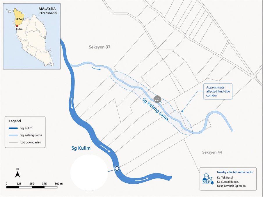
In Kulim, Kedah, a river has been taking land from people who never agreed to give it up. Nobody sold it. Nobody signed anything. The river simply moved in.
Older residents still remember Sg. Kélang Lama as a parit gila, a monsoon stream that carried off the extra water after a downpour. Back then nobody feared it. It was just there, doing a quiet job. Nobody lay awake wondering if it might one day swallow the ground beneath their house.
But the little drain was never on its own. Sg. Kélang (pronounced ‘kilang’) Lama is a tributary of Sg. Kulim, one of the many small channels threading toward the main river. What it carries down is not just water. Sediment and erosive force travel with it, wearing at everything in its path.
What actually moves a river
The name kilang lama, old factory, points back to an industrial past. This stretch of Kulim’s tin-processing district was dug open, then reshaped into plantations, settlements and roads. The parit gila that villagers remember never ran through untouched land. The ground had already been turned over long before anyone thought to worry about it.
For years it was just a modest drain, and people treated it that way. But runoff now arrives faster and in greater volume. The channel has stopped behaving like a drain at all. It carries itself like a working river.
Over two decades the old parit has widened, deepened and wandered off its course. One landowner who once held 18,000 square feet is now down to about 10,000. At RM25 a square foot, that is roughly RM200,000 of family wealth gone, washed away without a single transaction.

Four villages in Mukim Lunas sit in the path of all this. Desa Lembah Sungai Kulim, with over 50. Kampung Dusun, with 80 households. Kampung Tok Rasul, with 40, and Kampung Sungai Badak, with over 100. Behind each of those numbers are families who built where the land once felt safe.

So how does a drain turn into a river? The tempting answer is to point at whatever happened last, the sand mining, the blocked culvert. But it is rarely that simple. A river almost never changes course because of one bad day, and the science here refuses to hand us a single villain. What shifts a river is the balance between water, sediment, slope and resistance. When the balance tips, the channel rearranges itself.
Sg. Kulim is a steep, sediment-active tropical basin, just 19.2 km long, draining 447 sq km. It rises from the western slopes of Gunung Bongsu and drops from around 500m to 20m above sea level within nine kilometres. Rainfall ranges from 2,000 mm downstream to over 3,200 mm in the mountains.
In a basin shaped like this, water has no desire to move politely. It picks up speed in a hurry. Change what sits on the land, and the river feels it almost at once.
A town built to shed the rain
Kulim’s modern growth only sharpened that sensitivity. In 1991 the federal government brought in JICA to draw up a master plan for the Kulim Hi-Tech Park, imagined as a big industrial platform to catch the electronics and semiconductor spillover from Penang.
The early planning language was thoughtful about drainage and landform. It talked about keeping the natural contours and going easy on cut-and-fill to create a green industrial park.
Then the park grew, and the town around it grew with it. Soft plantation and estate land that once soaked up rain was paved over with roofs, roads, and factories. Something was built on the land, yes, but something else changed too. The water itself learned to move faster.
Researchers at Universiti Sains Malaysia put numbers to this. Rivers, they note, adjust to whatever changes around them, human activity included. Shift the hydrology and the sediment, and you reshape the channel itself, its cross-section, its stability, its capacity. They found that Sg. Kulim’s cross-sections had already changed after the major floods between 1991 and 2003, well before the bigger ones struck the district in 2010 and 2025. Their modelling confirmed the riverbed was wearing down along a 14.4 kilometre stretch. When a river deepens, its banks grow steeper, weaker, and far quicker to give way.
Sg. Kélang Lama keeps a record of how our thinking changed. We went from land that quietly drank the rain to land built to push the rain away as fast as possible.
It helps to stop picturing a river as a pipe carrying water from one place to another. A river is a moving body of sediment. It hauls sand, silt, gravel, broken branches and raw energy along with the flow. Add more water and the river adjusts. Add more sediment and it adjusts again. Push both at the same time, and the river may quietly begin to redraw itself.
That, by every sign, is what Sg. Kélang Lama is now doing.
In October 2003 the flood downstream at Ara Kuda peaked at 92.90 m³/s, the highest discharge anyone had measured across the 1960 to 2005 record. This was only a whisker below the estimated 100-year figure of 94.08 m³/s. It was a glimpse of what the basin can throw out when heavy rain, steep headwaters and paved-over land all line up at once. Then it happened again in 2010, and again in 2025.
Here is the part that catches communities off guard. Floodwater pulls back. The damage does not. Banks keep shifting. The bed keeps dropping. The bends keep creeping sideways. A river has a long memory, and somewhere in all of this the sleepy Sg. Kélang Lama came back to life.
Standing on the edge
Stand at the affected stretch and the damage is impossible to miss. The banks rise steep and raw. Pale soil stares back at the water where plants once gripped the edge. The RM200,000 gabions that Jabatan Pengairan dan Saliran (JPS) put in to hold the line have been battered loose or tipped over. The bank is now said to be within three metres of a village road, the SADA (Syarikat Air Darul Aman) water pipes and TNB infrastructure. For some families, the moving edge is right outside the door.
Residents count eight families in immediate danger in Kampung Sungai Badak. The next collapse might come with a single storm or take a few more monsoons. One resident put the fear plainly. “Every time it rains, we would lose sleep, fearing which part of our orchard or house will be swallowed by the river.”
The community also points downstream, at the sand mining. There are two operations, they say. One is licensed but lethal; the other works illegally, often under cover of night. The concern holds up scientifically. Pulling sand out can throw off the sediment balance, drop the riverbed, and set off adjustments upstream or along the reaches connected to it.
The fairest way to read it is this. Sand mining is unlikely to be the whole story of Sg. Kelang Lama on its own. What it does is pile one more disturbance onto a basin already reshaped by development, drainage and flood after flood.

A river no agency owns
The law, Kanun Tanah Negara, works in fixed lots, neat boundaries drawn on a plan. A river ignores all of that. It reads the world in slope, sediment and energy, and moves accordingly.
When Sg. Kélang Lama was just a small drain, land titles, roads and houses could sit comfortably close to it. Once the channel widened and began to move, what people owned on paper no longer matched what was left on the ground.
The river pulls in authorities, the technical agencies, the utilities and the residents themselves. Each one holds a piece of the problem. The river, for its part, ties every one of those pieces together.
Kulim’s predicament is one that many emerging economies will recognise. The river is a single system, yet the government keeps seeing it in pieces. JPS sees hydraulic risk. Pejabat Tanah sees titles and reserves. Majlis Perbandaran Kulim see drainage and development control. Mining regulators see sand extraction permits. SADA and TNB see their assets left exposed.
The residents, meanwhile, see their inheritance dissolving into the water. One community leader said in plainly in Kedah slang: “Kita bukan anti pembangunan, tapi mana boleh pembangunan negara mampan, penduduk mampuih.” They are asking why the country’s progress should be called sustainable if the people living beside it are left to perish.
Climate change now leans on this broken arrangement. As climatologist Dr Fredolin Tangang has noted, every 1°C of warming allows the air to hold roughly 7% more moisture, more fuel for the rain. In a steep basin like Sg. Kulim, that means faster runoff and greater force moving through channels already under strain. A fragmented governance system is therefore increasingly dangerous.
Be they here or in developed countries, no river corridors ever get fixed while each institution guards only its own patch. What Sg. Kélang Lama and Sg. Kulim need is one shared strategy for the whole corridor, rather than a string of disconnected fixes that never quite add up.
Such a strategy also needs a way to fund itself. There is a fair principle close at hand, and an old wisdom. Those who draw from the well should help keep it full. The factories of the Kulim Hi-Tech Park draw water at a heavily subsidised tariff and occupy the paved ground that accelerates the runoff, yet none of that advantage has flowed back into the basin bearing the consequences. A genuinely green industrial park would treat resilience in the basin as part of its operating cost.
When landowners lost ground to the river, the state had no mechanism for compensation. Its answer was a cut in quit rent, from RM16 to RM14 annually - an acknowledgment, on paper, that the land had simply grown smaller. A drop in the ocean for a family whose six-figure asset had vanished.

The unseen cost
The river has quietly become a cost of development that nobody put a price on.
Urbanisation shows up where everyone can see it, in land values, factories, and roads. Rental income, too. A two-room house in Kulim can fetch RM750 a month, but only while the land beneath it holds. The bill arrives somewhere much quieter, in the shape of backyards that are no longer there.
Sg. Kélang Lama deserves to be read as more than a small erosion complaint and an isolated case. It is an early warning from a watershed changing under our feet. The response has to start by seeing the river whole. It is water to be drained away, yes, but it is also a corridor of sediment, land, infrastructure, memory and risk. Until that happens, each fix will remain a bandage too small for the wound.
We can no longer ask whether Sg. Kélang Lama counts as a drain or a river. The real question is what kind of society lets a river change this much, this fast, before it finally listens to the people living on its banks.

Special thanks to APPGM-SDG and Persatuan Penduduk Desa Lembah Sungai Kulim for guiding the fieldwork and analysis.


Comments